Not mentioned in my Bio, I played bassoon. Okay, now I feel better after that confession. A while back I decided to pick it up again, so I made some reeds (I still know how) and gave it a try. It took a while for everything to come together, sort of, and I knew it was well past time to have the instrument serviced. A colleague told me of a repairman in Pasadena who does wonderful work, so I contacted him and arranged for a time to drive down and leave it for him to repair. Then I heard there was going to be a group of photographers who were gathering in Southern Utah to photograph Snow Canyon State Park, Zion, and Bryce Canyon National Parks. The time frame was perfect. I could drive to Pasadena, drop off the bassoon, do the Utah Workshop, drive back to Pasadena, pick up the bassoon, and drive back home.
So, here’s how it went. I drove from the Bay Area to Pasadena and dropped off the bassoon. I stayed that night after having a fine dinner at the historic Denny’s restaurant on the Old Route 66 which is one of several establishments in the area that exemplifies the Googie style of architecture.

Googie style of architecture in Pasadena, CA
The next day I drove to Barstow and found there was an area called Rainbow Basin, just a few miles north of town. The map shows that the route makes a loop from Barstow to the basin and back around to Barstow. On the way to the basin, driving through the desert, I was surprised to see a boat, moored in the sand. I had to turn around and photograph that as it seemed so out of context. There was no water for miles around!
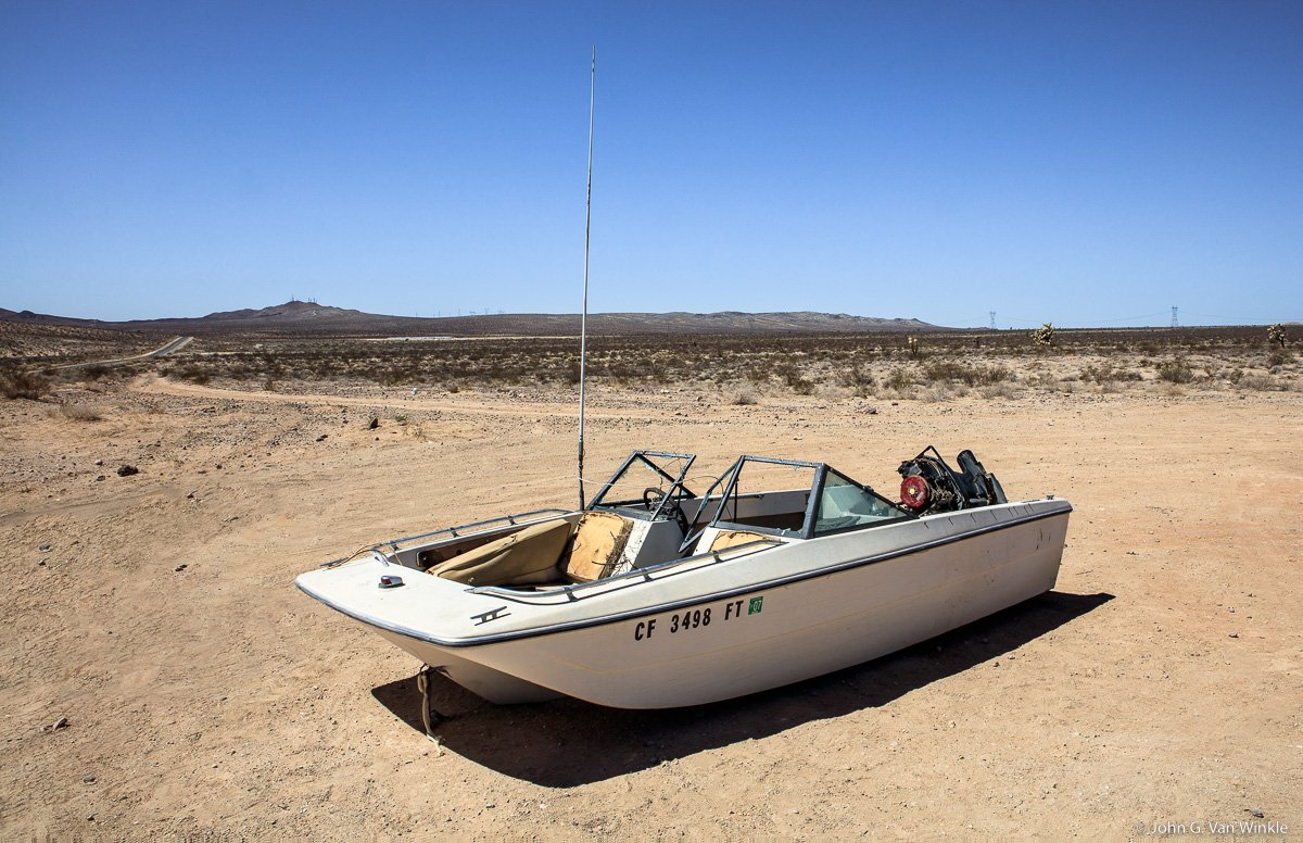
Waiting for a flood?
After turning left off the main road, I was driving on a dusty, hard-pan road where I eventually turned right onto an even dustier road which then forked to a one-way road that loops through the basin. It was late afternoon when I reached the basin, so I stopped briefly in several locations to photograph various geologic features. I even found a couple of ‟faces” to add to my collection of Faces of Nature, and a Few Others.

Cracked “Face”

How many “faces” do you see?
At one time this part of the Mojave Desert was a lush marsh and there are many fossils embedded in the stratified layers of the uplifted walls. Besides fossil insects, there are leaves, camels, small horses, smilodons, and mastodons. Not much lives in the basin these days. Vegetation is low lying and sparse, and Joshua trees dot the landscape. There are the usual rattlesnakes, desert rodents, and bugs.
The road narrows as the walls on either side form a canyon. At one point, I stopped to see if my car would fit through a narrow passage with large loose rocks as the roadbed. It looked barely passable, so I gave it a try. It was a tight, bumpy squeeze, but the car got through it unscathed. I could see that once past the narrow portion the road widened so I proceeded up and out of the canyon.
At the top of a knoll, since I was the only one for miles around, I stopped in the middle of the road, such as it was, to photograph the colorful layers of the walls that rise above the basin.
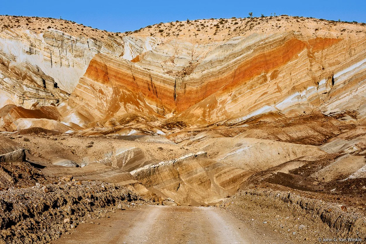
The road from Rainbow Basin
It was nearing sunset as I was leaving the basin, so I stopped to take one last shot of the sun setting through the limbs of a Joshua Tree.
Mojave Desert Sunset
Arriving back in Barstow, I had a wonderful Mexican dinner in the restaurant that was connected to the motel where I spent the night.
The next morning, I drove straight through Las Vegas and on to St. George, Utah. Highway 15 goes through the northeast corner of Arizona where the landscape changes dramatically from relatively flat high desert to the high, narrow, Virgin River Gorge which is quite spectacular. One can have a sense of feeling claustrophobic after experiencing the expansive views in the Nevada desert.
Arriving in St. George, I had some time, so I drove around to check out the geology and to acquaint myself with the area that I was going to be photographing the next day. My initial impression of the area was ORANGE. Lots and lots of ORANGE. The cliffs, sound walls around private communities, retaining walls, walls of buildings…ORANGE! The color is due to quartzite sand that once covered the area, indeed most of Utah. The sand formed dunes that were later buried, hardened into stone, and subsequently eroded by wind and water that carved the canyon. On top of the formations, you see dark patches of lava that were deposited at different times, from about 1.4 million to 27,000 years ago.
I stopped several times to photograph different rock formations that had been weathered in interesting ways. Quite often people were climbing either up the side or finding their way to the top of less steep formations.

Climbing the rocks around St. George, Utah
The weather was very pleasant as evening approached. Indeed, it was pleasant the whole trip which started 1 April and went through 10 April.
The workshop group, led by Joe Brady, gathered at 3:00 PM the next afternoon. Joe had led groups in the area before, so he knew routes, best times of day to photograph specific formations, restaurants, and most importantly where to get a good cup of coffee. His workshops are about getting the composition right and we talked about how to post-process our images. This was done with no pressure. He would guide us to an area, make a few suggestions, and let us loose to photograph. Occasionally he would look at what we were seeing through our cameras and would make suggestions as to what we might do to make a better image.
After introductions in the motel lobby, we headed to Snow Canyon State Park and photographed various features while climbing to the top of one of the petrified sand dunes. There were interesting patterns in the dune, and an occasional low juniper tree that had established a foothold in the rock. Scattered around the dune we found lots of Moqui marbles that ranged in size from approximately 2 inch (5.08 cm) in diameter to smaller that a pea. Moqui marbles are iron concretions that have eroded away from the cross beds of Navajo Sandstone found in this and in other areas in southern Utah.

Moqui Marbles and Weathered Tree, Snow Canyon, Utah
After gathering for dinner and downloading the day’s files, it was off to bed, with an early rise to again photograph Snow Canyon, then travel on to Zion National Park. We reached Zion around noon. The plan was to meet at the Visitor Center and take the shuttle (private vehicles were not allowed at that time of year) to the Temple of Sinawave, the last stop. I cruised the parking lot at the Visitor Center for almost an hour and finally found a parking place, made it to the shuttle, and eventually the meeting place. We photographed our way up the Riverside Walk to where the narrows begin but did not cross the river to wade on up to the narrows. That may be for another time, when arriving earlier in the day would afford an extended excursion up the river and be able to make it back to catch the last shuttle. We were warned by the driver, several times, to be sure to make it back to catch the last shuttle at 7:00 PM or we would have an eight-mile hike back to the Visitor Center.
We stayed in a motel outside of Zion National Park and the next morning headed to Bryce Canyon which included a stop to climb to the top of the Canyon Overlook Trail. This is a rather steep, and at times very narrow climb along a trail that had just a few railings along areas of the sheerest drop-offs. There were a couple of places what were wet which had me leaning into the side of the cliff and looking for hand holds. The climb was well worth the effort. The trail ended at a steep drop-off and a panoramic view of the canyon below.

View from the Top of the Canyon Overlook Trail
After lunch, and pie, and checking in to another motel, we headed to Bryce Canyon with a stop at Red Canyon to photograph the hoodoos. This area is often ignored by tourists eager to get to Bryce Canyon. It’s also a good area to find several naturally occurring ‟faces” to photograph.

Hoodoos, Red Canyon, Utah
The road approaching Bryce Canyon doesn’t reveal the view of the canyon or the thrill of seeing it for the first time, but a short walk to the canyon edge left me speechless seeing the grand view below. I stood there in awe, wondering how in the world I was going to photograph what I was feeling while looking down at so many years of geologic history. We photographed the canyon at sunset from Sunrise Point because all the other photographers were congregated at Sunset Point. The next morning, we got up early and drove back the park to photograph the sunrise at Sunset Point…Same reason. The rest of the day at Bryce was spent at various stops in the park, each one just as exciting as the last.
Our last night was in Springdale. That evening I got a text from the person overhauling my bassoon, saying that it would not be ready for pick-up on my return to Pasadena, so I said something like ‟The best laid plans…” and cancelled my motel reservation in Pasadena.
The final day of the workshop was another stop at Snow Canyon. This time we climbed into and above the Whiterocks Amphitheater to get shots of white Navajo Sandstone that is another grouping of petrified sand dunes in the north part of the park.

Joe Brady standing in the Whiterocks Amphitheater shows the scale of the petrified sand dunes.
After dinner in St. George, some of the group returned to the park for sunset shots. We didn’t have a grand sunset, but there were a few clouds that picked up some color for a few minutes, and then there was nothing.

Sunset over the lava-capped petrified sand dunes. Snow Canyon State Park, Utah.
Early the next morning I headed back to Barstow. This time, I took a side trip to take some pictures of an old train depot in Kelso, California, at the request of my son-in-law who likes all things trains. Kelso is entered in a rather substantial list of California ghost towns and was most active during short lived mining operations for borax, iron, gold, and silver in the 1940’s. The depot, which is now a visitor’s center, and under renovation, opened in 1905, had a hotel and restaurant available for passengers and employees. The depot ceased operation in 1964 and the restaurant closed in 1985. The Depot Visitor Center is supposed to reopen in the Spring of 2023.

Kelso Train Station
When I got to the restaurant in Barstow, it was packed. I found out that it was reserved for the hundredth birthday celebration of a local lady, and I had just missed hearing the Mariachi band that was hired for the event. I would liked to have heard the band play. Back in the room, I took some time to download my files from Kelso, rested a bit, and was able to have dinner once the crowd thinned out.
Heading for home the next morning, I set the cruise control to the speed limit, moved over to the right lane so everyone could pass me, and made my way back to the Bay Area.
But wait! I just heard that my bassoon will be ready sometime in July, so I am looking forward to another road trip!!